In this guide
A useful fishing waypoint records a reason to return, not simply a place where the boat happened to be. Begin by understanding the map’s depth units, scale and limitations, then combine it with observations. Keep fishing interpretation separate from the chart and navigation decisions that get you there safely.
Read the map’s language first
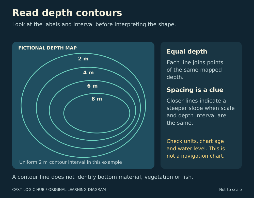
NOAA describes soundings as individual depth measurements and contours as lines connecting depths. Before interpreting an edge, inspect the legend and display settings. A value in metres is not a value in feet, and changing the display scale does not create a new survey.
On a consistent contour interval, closely spaced lines describe a steeper change than widely spaced lines. Compare spacing within the same map scale and interval. A tight-looking section may otherwise be a product of the chart presentation. NOAA documents how different source scales and contour intervals can produce discontinuities between electronic-chart cells.
A navigation chart carries information such as obstructions, aids to navigation and depths. A recreational fishing layer may be useful for planning a search, but its attraction as a fishing map does not establish that it supplies all the navigational information your vessel needs.
A six-step desk exercise
- Write down the map provider, coverage area, version or update date when available, depth units and relevant reference datum.
- Locate the launch or access point, permitted fishing area and an alternative exit. Mark restrictions and hazards before fishing features.
- Select one uncomplicated feature to inspect, such as a point extending toward deeper water.
- Trace its shallower side, deeper side and transition. Describe the shape in plain language before assigning a fishing theory.
- Plan a safe inspection route using the appropriate navigation information. A straight line between two fishing marks is not automatically a safe route.
- Write the question you will test: for example, whether the mapped edge is apparent on sonar and whether your presentation can follow it controllably.
This turns the chart into a search plan. It also gives you a reason to reject a location when the access, chart detail or conditions are inadequate.
Verify the feature on the water
Check depth with equipment set up according to its manual, while maintaining a proper lookout. Note differences between the chart and observations rather than forcing them to agree. Water level, the chart’s reference level, the instrument’s configured depth reference and survey detail can all matter when comparing numbers.
A brief inspection may be enough to decide that the area deserves a closer look. It does not justify removing a charted hazard or asserting that an uncharted route is safe. Record an uncertainty in the waypoint notes and use the relevant navigation authority’s correction or reporting process if appropriate.
Use a waypoint format that preserves meaning
| Field | Useful entry | Why keep it? |
|---|---|---|
| Name | North point, edge observed | Identifies the feature without a claim about fish. |
| Evidence | Mapped contour; repeated sonar pass | Separates observation from expectation. |
| Date and conditions | Visit date, water level context, wind | Makes changes easier to recognise. |
| Position type | Boat position or selected feature position | Avoids confusing the two locations. |
| Next test | Inspect the deeper side | Gives the next visit a purpose. |
Use your device’s documented method to create or select a position. Saving the boat’s current location after noticing an older sonar return may save a different point from the feature you intended.
Organise and protect the record
Group marks by water and purpose: access, navigation caution, observed structure and fishing results. Keep a backup in a supported export format and test that you can reopen it before deleting the original. Retain the coordinate format and datum information if your export workflow requires them.
When sharing a guide or catch report, use a general area unless you have a clear reason and permission to disclose more. Your personal success at a location does not grant public access, and sensitive habitat should not become a public target simply because a coordinate is easy to copy.
Questions from the bank
Keep it helpful. Comments are moderated. Do not share precise locations or personal information.
No approved comments yet. Ask a practical question or share what you learned.