
In this guide
Use a lake map to choose a small set of places worth investigating, then verify what is actually there. A point on a chart, a vegetation edge and a dock are different kinds of information. Combining them thoughtfully is more useful than collecting a long list of attractive-looking spots.
Separate structure, cover and food
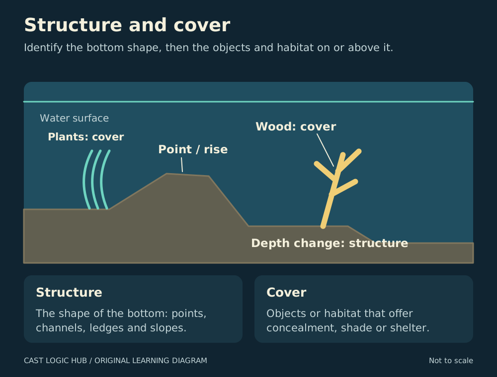
Missouri’s conservation guidance uses structure for bottom features such as points, ridges and drop-offs. Cover includes objects or shelter such as vegetation, timber, docks and shade. Food is a third consideration. A feature can provide both a shape change and protective cover, but the words describe different jobs.
This distinction improves your notes. “Rocky point with vegetation on its sheltered side” tells you more than “good structure”. It also suggests two separate tests: the depth change and the edge of the plants. Neither feature guarantees that feeding fish are present.
| Information | What it helps explain | What it does not prove |
|---|---|---|
| Contour map | Recorded bottom shape and depth | Current fish location or safe navigation everywhere |
| Visible cover | A potential shelter or ambush feature | How far it extends underwater |
| Prey activity | A possible feeding opportunity | Which predator is present |
| Survey record | What sampling detected at a stated time | A real-time count of fish at your position |
Read the source before the map
Check the survey date, depth units and any stated water-level reference. Minnesota DNR’s LakeFinder combines maps, fish surveys, aquatic plant information and access records, but explains that not every lake has been surveyed and recent results can take time to appear. Treat gaps as missing information.
If the map lacks a reliable date or reference level, avoid recording an exact working depth from it alone. Water level and the age of the survey can change how useful that figure is. A fishing map is a planning aid, not permission to cross shallow water at speed.
Build a three-area plan
- Pick one obvious feature that matches the target species’ known habitat, such as a rocky point or a vegetation edge.
- Choose a second area with the same broad feature but a different exposure, depth or cover arrangement.
- Choose a third area that tests a different explanation, rather than another nearly identical location.
- Write why each is on the list and how you can approach it legally.
- Set a practical time budget that leaves room to inspect, fish and move without rushing boat operation or access.
The three-area plan is a learning exercise, not a rule that three places are enough. Its purpose is to make the search explainable. If the first two areas produce no evidence, the third asks a new question instead of repeating the same assumption.
Fish a feature in layers
Start with a casting lane that you can retrieve safely. Compare the shallow side, the edge and a deeper route where your method can reach it. Keep the lure or presentation stable during the first comparison so that a location change is not confused with a tackle change.
Minnesota’s smallmouth guidance identifies rocky shorelines and points extending into deeper water as useful habitat. Its largemouth guidance emphasises vegetation and protective cover. These are regional examples of species-related decisions, not a promise that the same outline on every lake holds the same fish.
Know when an attractive feature is a poor choice
A feature may be inaccessible, unsafe in the wind, too rough for the tackle available or difficult to fish without damaging habitat. Choose another route. Do not reduce leader strength solely to reach an area from which you have no realistic landing plan.
Plants can also prevent the lure from fishing properly. Inspect after a pass. Repeated fouling tells you the presentation needs a different path, working depth or form. It does not demonstrate that the entire feature is unproductive.
Turn the result into a better search
Record which part of the feature you actually fished, the presentation depth you could control and any observed prey or fish. Separate map interpretation from direct observation. “Chart suggests a drop; three clean casts along the plant edge; no contacts” is an honest result that supports the next decision.
Questions from the bank
Keep it helpful. Comments are moderated. Do not share precise locations or personal information.
No approved comments yet. Ask a practical question or share what you learned.